From: Revista de la Sociedad Boliviana de Botanica 4(1): 51-65, 2003
The genus Bromelia (Bromeliaceae) in Bolivia with the description of two new species from the Santa Cruz department Roberto Vasquez & Pierre L. Ibisch
Bromelia serra GRISEB., Abh. Konigl. Ges. Wiss. Gottingen 24: 328. 1879.
TYPE: Argentina. Lorentz & Hieronymus s. n. (LT: GOET).
GEOGRAPHICAL RANGE: Bolivia, Paraguay y Argentina. In Bolivia: departments of Beni, Cochabamba, La Paz and Santa Cruz.
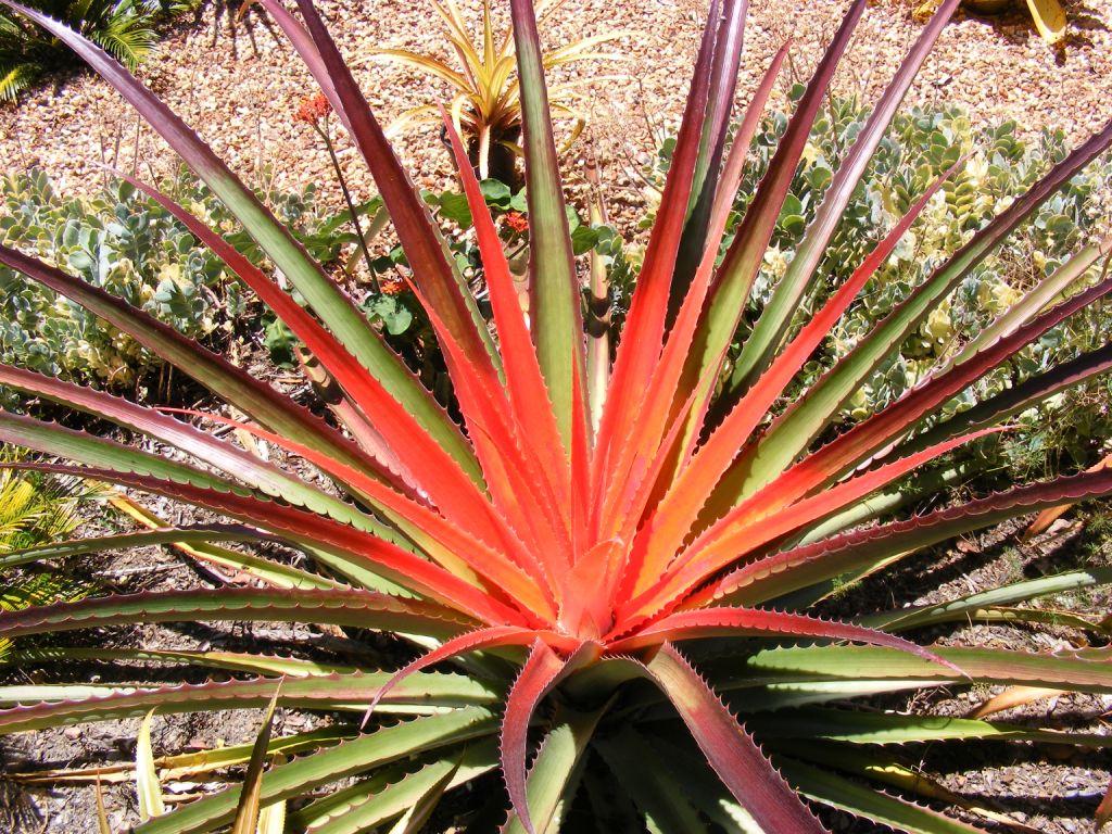
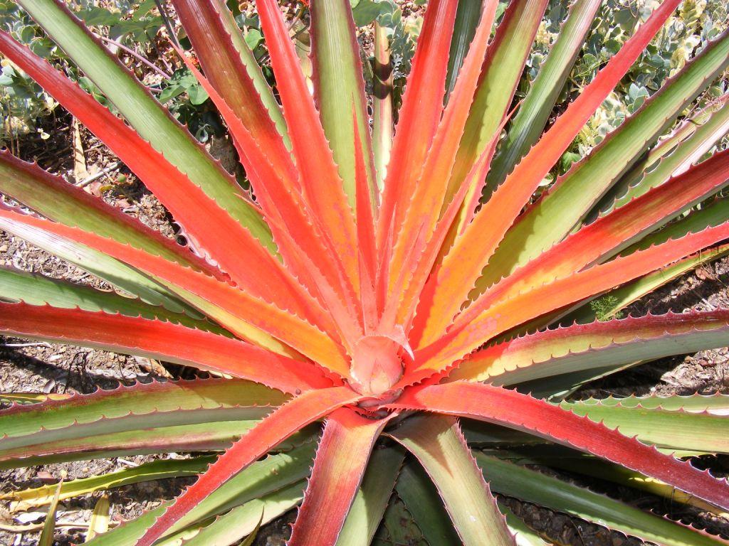
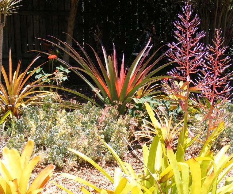
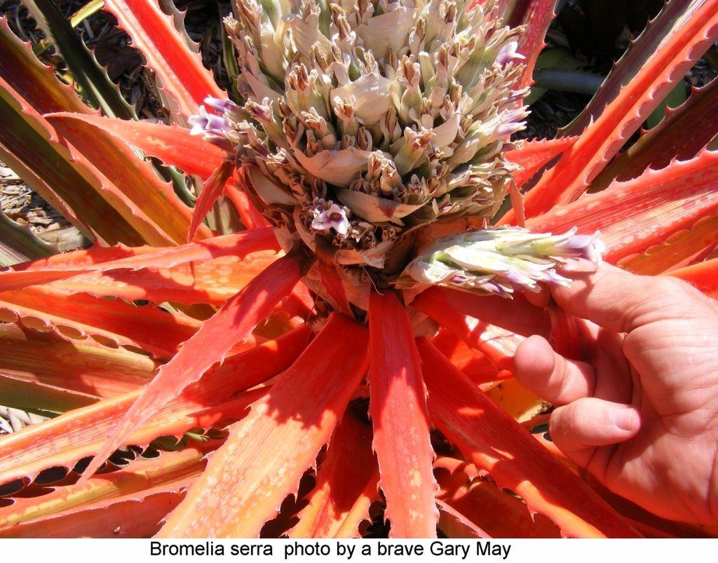
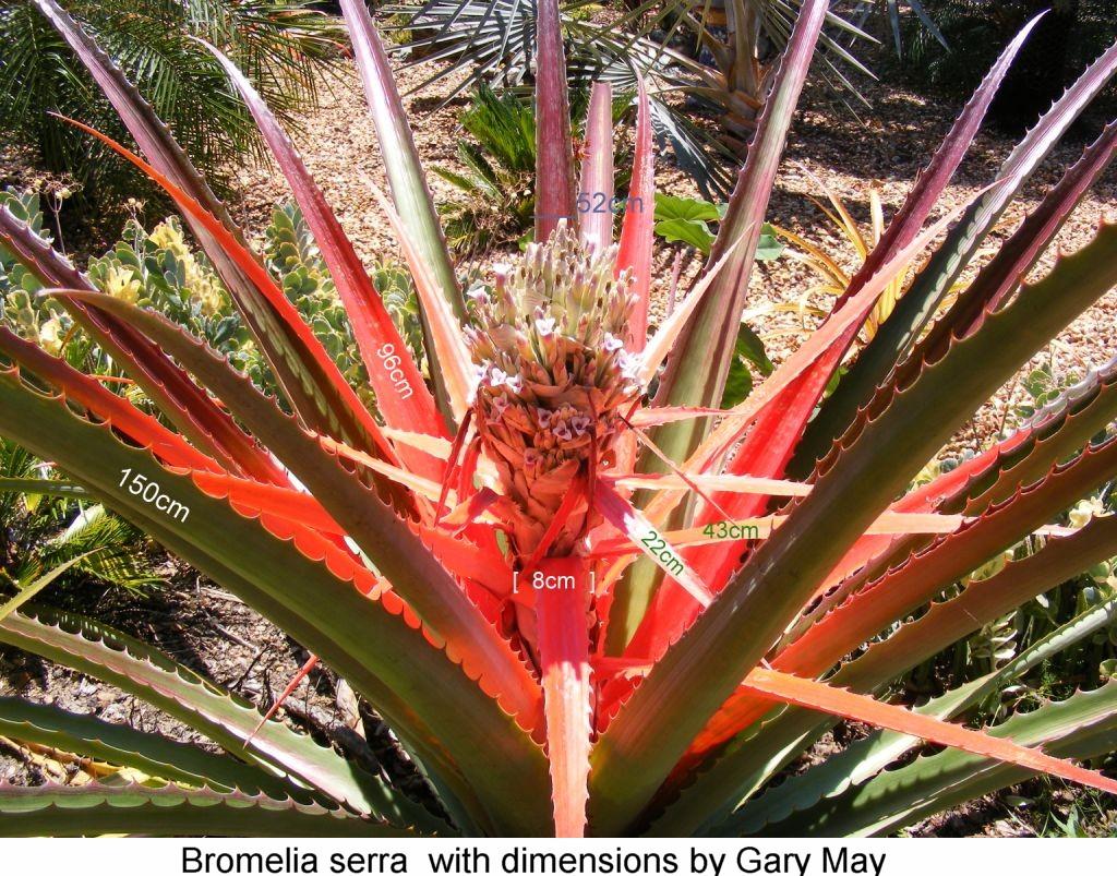
Plant terrestrial, to 50cm high.
Leaves 1-1.5m long, 3-5cm wide, with a serrate margin, with antrorse and retrorse, unciform spines; apical ones red at maturity.
Scape short. Bracts subfoliaceous, red.
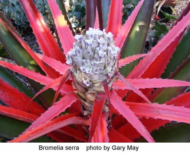
Inflorescence capitate.
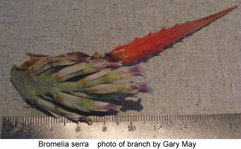
Flowers in short fascicles, 5-9 flowered.
Sepals free, 15 x 5mm, white.
Petals white with a violet band towards the apex, connate at base.
Anthers yellow.
Fruits yellow when ripe, edible. Fig. 7.
RECORDS IN BOLIVIA: BENI: Prov. Ballivian: Espiritu, in the zone of influence of the Rio Yacuma, 200m,13 Apr. 1980, S G. Beck 2533 (LPB); ibid.: EBB, 40 km E of San Borja,l4°50'S, 66'40'W, 200m, 16 Apr. 1991, T. Killeen 2864 (LPB); Prov. Cercado: Trinidad, Misiones Guarayos, Sep. 1926, Werdermann 2300 (LPB, S); Prov. Maraban: 30 km of Trinidad to San Joaquin, 14'10'S, 64'50'W, 2 Nov. 1993, M. Moraes et al. 1473 (LPB, SEL); Prov. Yacuma: Beni Biological Station, Estancia El Porvenir, nearby station, 14'50'S, 66°20W 250m, 12 Jul. 1988, E. Vallanueva et al. 858 (LPB); ibid.: 23 Dec. 1988, M Moraes 944 (LPB); Prov. Mamore: 7 km S of San Joaquin toward Trinidad, 150m, 7 Nov. 1993, M. Moraes et al. 1631(SEL). COCHABAMBA: Prov. Ayopaya: Atispaya,1,340m,16°36' S, 66043'W, terrestrial in dry inter-Andean valley with deciduous forest at the transition towards a humid forest, 22 Jun. 2001, R. Vasquez, G. Navarro, M. Fernandez, F. Miranda & H. Rocha 4159 (VASQ). LA PAZ: Prov. Franz Tamayo: Rio Bilipisa, 10 km NW of Apolo, 14°36' S, 68'27'W, 1,100m, 5 Jul. 1997, M. Kessler, J Gonzales, K Bach, L Jimenez & A. Portugal 11037 (LPB, SEL, GOET); Prov. Iturralde: Luisita, 13 '05'S, 67°15'W 180m, 28 Febr. 1984, SG. Beck & Haase 10102 (LPB). SANTA CRUZ: Prov. A. Ibanez: Canton Terevinto, Hacienda Arubai, 480m, 17Y'41' 19"S, 63Y'25'24"W, terrestrial in transitional habitat between Cerrado savanna to humid forest, 1 Dec. 1999, R. Vasquez & J. Coimbra 3469 (VASQ); ibid.: International Airport of Viru-Viru, Warnes, 17°39'46"S, 63°69'24"W 380m, 3 Febr.1994, M. Menacho & Sea 364 (USZ); Prov. Chiquitos: 1945, Weddel13520 (P); ibid.: 55 km from San Jose a Quimome, 380m, 17°42'S, 61°14'W, terrestrial on rock outcrops within Cerrado, 14 Jul. 2002, R. Vasquez, D. Ric & A. Osinaga 4567 (VASQ); Prov. Cordillera: Izozog, May 1934, Cardenas 2756 (GH); Campo Leon, 150 km southeast of Santa Cruz de la Sierra, 350m, terrestrial in dry Chaco forest, 12 Sept. 1999, R. Vasquez, et al. 3362 (VASQ); ibid.: Curuyuqui, 50 km SE of SC on rio Parapeti, 18°45'S6"S, 62°13'S9"W, 350m, 25 Oct. 91,A. Gentry et al. 75214 (USZ); ibid.: Charagua, 5 km from the town, Rio Ovai, 19'46'S, 63'1 2' W 800m, 13 Apr. 1990, I. G. Vargas 471(USZ); ibid.: Banados del Izozog, Estancia Cachari, 410m,14 Mar. 1991, G. Navarro & I. G. Yargas 394 (USZ); ibid.: Copere, 16 km S of Las Brechas, 19'40'S, 62'08'W, 12 Oct. 1992, M. Hllegas et al. 260 (USZ); ibid.: Boyuibe, 55 km towards the border with Paraguay, via F. Villaz6n, 620m, 4 Oct. 1983, S.G. Beck & M. Liberman 9418 (LPB); Prov. Florida: N of Pena Colorada, ca. 1,300m, terrestrial on slopes with deciduous Chaco Serrano forest, 13 Oct. 1999, R. Vasquez, F. Quispe, et al. 3400 (VASQ); ibid.: 5 km of Mataral on road to Vallegrande, 18°09'S, 64°13'W 1,400m, 15 Dec. 1990, M. Nee 40291 (USZ); ibid.: 2,5 km NE of main highway at Mairana, quebradaYesera,l8°06'30"S, 63°57'W 260 m, 27 Jan. 1994, M. Nee & I. G. Yargas 44673 (USZ); ibid.: Refugio Los Volcanes, 3 Km al NE de Bermejo,l8°06' S, 63'36'W, 1,050m, 5 Oct. 1997, M. Kessler J. Gonzales, K. Bach & E. Rapp 12337 (LPB, SEL, GOET); Prov. A. Ibanez: 30 km east of Cotoca, between La Bola and the Rio Grande, 280m, in dry Chaco forest, Mar. 1990, R. Vasquez 1853 (VASQ); ibid.: 26 Oct. 1999, R. Vasquez, P. Ibisch, M. Nee et al. 3416 (VASQ); Prov. Ichilo: 13 km NE of Buena Vista on highway to Portachuelo, near turnoff to San Javier, 17°24'S, 63°34'W 300m, 21 May 1991, M. Nee 40504 (USZ); ibid.: 13 km NE of Buena Vista on highway to Portachuelo, 17°24'S, 63°34'W 300m, 21 May 1991, M. Nee 40504 (LPB); ibid.: 4 km N of Buena Vista on road to Laguna Madrejon,l7°25'S, 63°40'W 315m, 31 Oct. 1990, M. Nee 39672 (LPB); ibid.: road from Buena Vista to Portachuelo, 10 km NE of Buena Vista, 2 km W of turnoff to San Javier, 17'24'S, 63'35'W, 300m, 6 Dec. 1989, M. Nee 37979 (LPB); Prov. Nuflo de Chavez: Lomerio, 12 km N of Las Trancas community, l6°31'13 "S, 61°50'47"W 450m, 12 Dec. 1995, F. Mamani & A. Jardim (USZ); ibid.: Estancia San Miguelito, Pascana WCS camp, 17-45'S, 61-47'W, 400m, 26 Jul. 1995, A. Fuentes 1148 (USZ); Prov. Velasco: Jul. 1892 Kuntze s. n. (NY); ibid.: Noel Kempff Mercado National Park, Serraniade Huanchaca, 13°59'5,60°43'W 800m, 3 Dec. 1987, W. Thomas et al. 5561 (USZ); ibid.: Bajo Paragua Forest Reserve, 5 km from the sawmill on the road to Empalme,l4°32' S, 61'30'W, 400m, 8 Apr. 1994, M. Saldias et al. 3 758 (SEL).
HABITAT: The Bromelia species with the widest distribution. It is found in lowland dry forests, as well as in dry to semihumid inter-Andean valleys and the montane Chaco and the Tucumano-Bolivian forest, from 150m to 1400m.
OBSERVATIONS: As in B. hieronymi, the young stems are consumed by the indigenous people of the Gran Chaco. In the quechua-speaking areas the plant is known as "chaguar" while in "guarani dominated" areas the species is called “caraguata” or "garabata" (ARENAS & ARROYO 1988).